About Seismic Monitor
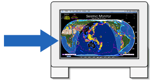
Seismic Monitor allows you to monitor global earthquakes in near real-time, visit seismic stations around the world, and search the web for earthquake or region-related information. You can also view seismograms and make dataset requests via its WILBER interface.
The date and time of the map (in Universal Time) are located in the lower right hand corner.
|
 |
|
|
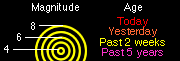
Earthquakes are shown as colored circles, where the size of the circle tells you the magnitude of the quake, using the legend at the top left of the map. Only earthquakes of magnitude 4.0 or greater are displayed. |
|
Circle Color
|
Age of Earthquake |
|
Red
|
the last 24 hours <-- animates briefly when page is loaded |
|
Orange
|
from 24 to 48 hours |
|
Yellow
|
from 3 days to 2 weeks |
|
Purple
|
from 2 weeks up to 5 years |
| The distribution of earthquakes over the past 5 years is represented by the purple dots and demonstrates how earthquakes define the boundaries of tectonic plates, as well as the relationship between topography and earthquakes. |
 |
 |
The Earth's shadow shows the line between day and night as well as the progression of the seasons. |
Instructions
 |
Click anywhere on the world map to open a zoom map for the region you clicked in. From that window you can click in the center of earthquake circles to get a list of recent earthquakes in that vicinity, or click on observatory stations (the small blue triangles) to bring up station information pages.
Buttons at the bottom of map include: |
 |
Bring the top level world map window to the front of screen. |
 |
Close this zoom window and return to the top level world map. |
 |
Display a list of the most recent 30 days of seismic activity for this region. |
 |
If you click on the Google checkbox, in a zoom map window to the right of the information display field, Google search mode is enabled.
When enabled, clicking on areas which are not earthquakes executes a search for information relating to seismicity and plate tectonics for the geographic placename you clicked on. |
Passing the mouse over the zoom map without clicking displays the names of geographic features as well as the times and locations of the earthquakes passed over.
Javascript must be enabled. Mac IE and Safari only: may need to click once anywhere or resize window to activate this function. |
 |
|
You can open a jumbo-sized map by pressing the
"See Large Screen View" button:
|
 |
 |
|
This map has no interactive capabilities. It is meant for unattended display on 17" and larger monitors in browser full-screen mode.
|
Seismic Monitor is updated every 20 minutes (jumbo-sized map hourly).
Left unattended your browser will automatically reload the page at about the same interval.
Earthquake data are provided by the USGS National Earthquake Information Center .
Supported browsers: (Mac/PC): IE V5+, NN V6+, Mozilla V1.2+, Mac Safari 1.0+
This website is still under development. We welcome your comments and your suggestions regarding its use in the classroom. Please send them to webmaster@iris.edu .
|